The map and list below shows the 21 study sites and researchers of Phase 1
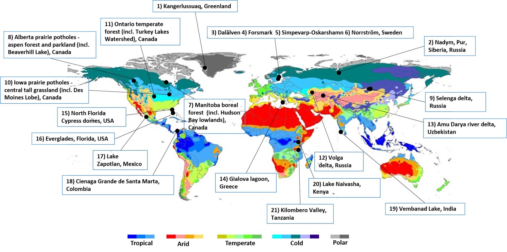
Map showing the locations of the 21 wetlandscape study sites of GWEN. The sites are shown on a background map of the Köppen-Geiger climate classification system, as updated by (Peel et al. 2007) and numbered according to Latitudinal position (Map modified from Thorslund et al. 2017).
Site descriptions and contacts
- Site 1-2: Arctic Wetland Areas (in map: site 1: Kangerlussuaq, Greenland; Site 2: Nadym and Pur River Basins, Siberia, Russia), Pan-Arctic Drainage Basin, Georgia Destouni
- Site 3: Dalälven River Basin, Sweden, Georgia Destouni
- Site 4: Forsmark Coastal Catchment, Sweden, Georgia Destouni
- Site 5: Simpevarp-Oskarshamn Coastal Catchment, Sweden, Georgia Destouni
- Site 6: Norrström Drainage Basin, Sweden, Georgia Destouni
- Site 7: Manitoba boreal forests (including Hudson Bay Lowlands), Ontario, Canada, Irena Creed / Brian Branfireun
- Site 8: Beaverhills Lake, Canada, Irena Creed
- Site 9: Selenga Delta, Lake Baikal Catchment, Russia, Sergey Chalov / Jerker Jarsjö/ Josefin Thorslund
- Site 10: Des Moines Lobe, USA, Nandita Basu
- Site 11: Ontario temperate forests, Canada (site description in preparation)
- Site 12: Volga delta, Russia (site description in preparation)
- Site 13: Amu Darya River delta, Uzbekistan (site description in preparation)
- Site 14: Gialova Lagoon, Greece, Georgia Destouni / Katerina Mazi
- Site 15: North Florida Cypress domes (Geographically isolated Wetlands), Florida, USA, Matt Cohen / Jim Jawitz
- Site 16: Ridge-Slough-Tree Island Mosaic, Everglades, USA, Matt Cohen / Jim Jawitz
- Site 17: Lake Zapotlán, Mexico, Irena Creed / Brian Branfireun
- Site 18: Ciénaga Grande de Santa Marta, Colombia, Fernando Jaramillo
- Site 19: Vembanad Lake System, Cochin Estuary, India, Georgia Destouni / Vladimir Cvetkovic
- Site 20: Lake Naivasha, Kenya, Irena Creed
- Site 21: Malagarasi-Moyovosi and Kilombero Valley, Tanzania, Steve Lyon / Jerker Jarsjö